September 21
Today we explored a very small part of the Natchez Trace
Parkway.
The Natchez Trace Parkway is a 444-mile recreational road
and scenic drive through three states. It roughly follows the "Old Natchez
Trace" a historic travel corridor used by American Indians,
"Kaintucks," European settlers, slave traders, soldiers, and future
presidents. Today, people can enjoy not only a scenic drive but also hiking,
biking, horseback riding, and camping along the parkway.
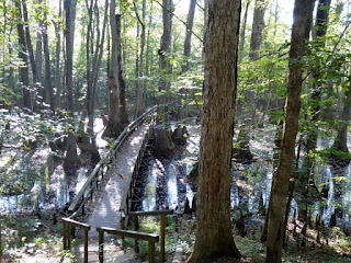
This stop is where the Pearl River flowed many years ago before it changed course. During periodic low water seedlings of water-tolerant Cypress & Tupelo trees started to grow. This aquatic forest is the result.
Choctaw Boundary
Pearl River
Chickadee
West Florida Boundary
Boyd Mound - two mounds became one
we walked a short distance on the trail - we did see some Cardinals, Jays and Thrashers
Blue-grey Gnatcatcher
Cinco de Mayo for lunch
I had really fantastic steak nachos. Really good tasting steak. Greg had tamales and said Sonya's are better.
It was a small museum that shows the stops along the parkway in all 3 states.
The Sunken Trace, at milepost 41.5 is one of the most
photographed sites along the parkway. The trace appears sunken in this spot due
to thousands of travelers walking on the easily eroded loess soil. This short
trail will allow you to walk on the Natchez Trace just as thousands have before
you.Also, the Mississippi Craft Market was close by so we stopped by. No photos allowed inside, but there were some glass pieces outside. They really did have some nice art and crafts inside.
After that, we headed home to get ready to move to our next location in Louisiana for a week.
We plan on 3 days in New Orleans and a couple in Baton Rouge. Not sure about the rest yet. It was hard to research since we had no phone/internet at our last RV Park. It's great here in Louisiana. It'll take me a few days to post for Louisiana as we will have some full days.


No comments:
Post a Comment